Map with GIS 7
Curriculum Connections:
- Geography - Physical Patterns in a Changing World (Plate Tectonics, Earthquakes and Volcanoes)
- Media Literacy - Create a Media Text for an Intended Purpose and Audience
Character Development:
- program emphasizes respect, responsibility, teamwork, perseverance and co-operation
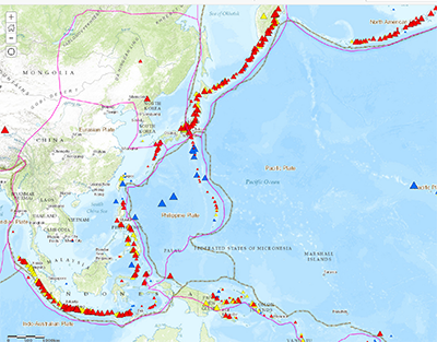
Students create a world map with tectonic plates, earthquakes and volcanoes, and make some observations about them. In the afternoon, using their map, they focus on 3 specific earthquakes and 3 volcanoes to create a Story Map. This requires students to research the 6 features for information and possible images.
This program uses ESRI’s latest "cloud" service, ArcGIS Online. This allows using robust GIS tools on any computer, including mobile devices, in a browser. Visiting classes will be given a special account, tied to the TDSB, to create maps at TUSC, and to continue using them back in class. As all the data lives "on the web", students can access and expand their maps from any computer.
If you'd like to explore the Help Movies the students will be using during the program watch below
This program does not have an outdoor component.
Please Note: the TUSC IT Lab is fully accessible for students in wheelchairs; contact TUSC for more information
Program Length: one day (9:30 am - 2:00 pm)
Availability: winter (December to mid-March)
Location: TUSC IT Lab
This program takes place in the TUSC IT Lab at Danforth CTI and will become available once operational procedures allow.
Fee: Please find information on the fee structure here.
User fees help ensure the continuation of these learning experiences through partial cost recovery; fee schedule reflect rates subsidized by the Toronto District School Board.
TTC: each student requires 2 tickets
Maximum: 30 students